

Is your city
courtyard urbanism ready?
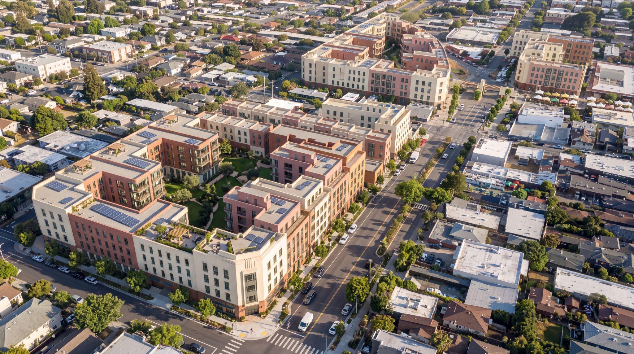
A neighborhood of courtyard homesThe opening image from the shared report · Report p. 1 · Concept illustration

NORTH SHATTUCK · BERKELEY · CONCEPT STUDY

Bring needed family housing to North Shattuck.

Alicia Pederson / Courtyard Urbanist
In collaboration with John J. Parman

North Shattuck’s shops, stores, clinics, and other small businesses form a walkable anchor for the surrounding residential district. Building on its streetcar-era identity, the proposal would strengthen a family-centered neighborhood with a distinct role alongside downtown Berkeley’s commercial hub. Compact courtyard buildings and townhouses on four opportunity sites would make room for family housing around protected shared gardens, with rental and ownership options that could help households stay as their needs change. The aim is to retain existing businesses, make room for more and connect everyday life through the neighborhood’s streets and pedestrian mews.

THE PROJECT FILM

From the existing site to the courtyard vision.

Watch the 71-second film from Alicia’s slide deck: the aerial, proposed plan, model tour and neighborhood illustrations.

Silent video. Press play in the player; use its timeline and full-screen controls.

Open film separately ↗

FAMILY LIFE SHAPES THE DESIGN

The homes, the shared yard and the neighborhood.

01

Homes with fronts and backs

Small groups of homes share a stair and lift landing. Homes can extend from the street to the courtyard, with windows on both sides and room for larger households.

Report p. 12 · A family kitchen opening onto the shared courtyard. Illustrative, with detailed dwelling layouts still to be developed.
02

A protected shared yard

Places to play, garden and spend time with neighbors, away from traffic. Suitable ground-floor homes could open to the garden; upper-floor homes share access through stairs and lifts.

Report p. 5 · Shared-yard concept illustration. Access and maintenance arrangements need further design.

03

Everyday life within walking reach

Homes above shops and passages through the blocks connect family life to the surrounding neighborhood’s services, schools and parks.

Report p. 7 · Shattuck frontage concept illustration. The proposed Walnut connection needs further agreements.

HENRY STREET MEWS

A front door on a sheltered mews.

Three-story homes with individual entrances offer another way to live around the block. The planted pedestrian mews beside the retained SenS Hotel brings neighbors together close to their own doorsteps.

Report p. 6 · Illustrative concept view. Any hotel-side connection remains conditional.
More life at ground level · Mews activity study
Additional concept illustrationMore life at ground level

Along the former-bank mews, individual entrances, planting and places to sit could make room for children to play and neighbors to meet close to home. Street-facing ground floors could also accommodate neighborhood businesses, with uses and occupants still to be determined.

Henry Street mews beside the former-bank site and retained hotel. AI activity study adapted from the report’s page 6 illustration; architectural details remain illustrative. Any hotel-side connection remains conditional.

Concept visualizations: Courtyard Urbanist. Images illustrate design intent and may differ from measured geometry; quantities come from the shared report. Neighborhood aerial map context: Apple Maps and its providers.

HOMES WITH FRONTS AND BACKS

How the homes meet the courtyard.

A shared stair and lift landing can serve a small group of homes, leaving room for windows toward both the street and the garden.

Report p. 11Two or three homes around one landing

Access prototypes compare two or three homes around a shared landing, with windows toward the street and courtyard.

Illustrative access prototypes, separate from the current site plan

Room for different households.

The report explores two or three homes around one landing. These diagrams explain the access principle; they are illustrative prototypes, separate from the current site plan.

Suitable ground-floor homes may open directly to the garden. Upper-floor homes reach the shared courtyard through their building’s stair or lift.

Fitted plans still need to establish bedroom mixes, accessible routes and how the homes work in detail.

THE MARKET PLAZA AND WALNUT CONNECTION

A market plaza and a pedestrian mews to Walnut

Detail from report p. 8

Close crop of the report’s page 8 illustration, showing the market plaza between Shattuck and Walnut. Original image detail is unchanged. Architecture: Courtyard Urbanist. Aerial context: Apple Maps and its providers.

A pedestrian mews through the south end of the CVS site and the JCC parking lot would connect Shattuck and Walnut at mid-block. It could provide a setting for the Thursday farmers’ market and additional small shops, encouraging more walking and activity in the neighborhood. The proposal also calls for narrowing Shattuck, with the aim of making crossings easier and safer and helping activate the corridor.

Access and land agreements, public approvals, detailed street design and market operating arrangements remain to be resolved.

THE NEIGHBORHOOD IN CONTEXT

Many buildings. Shared gardens. Connected streets.

From the whole-neighborhood banner above, look closer at the northern blocks and the four-site schematic plan.

FOUR SITES, ONE COORDINATED STUDY

Explore the housing opportunity.

Safeway, CVS, the former bank and Andronico’s. Select a site to see its measured allowance, or explore all four together.

Market to Walnut: the proposed pedestrian mews through the south CVS site and JCC parking lot would connect the two streets at mid-block. Access and land agreements remain unresolved.

Explore the neighborhood

The interactive map opens here automatically as you reach this section.

CONCEPT ILLUSTRATION · LOADING LIVE MAP

The interactive map opens here.

It loads automatically. Then pan, zoom, select a site or switch to the plan and market views.

Preparing the architectural model…

Drag to pan · Two fingers to zoom/rotate · Mouse wheel to zoom
Map layers & model notes

Original Walnut market model. Streets and neighboring building heights are schematic; GIS boundaries are not a survey. The SenS Hotel is retained and excluded from new capacity. Internet access is needed for the basemap.

Open model in its own window ↗Download the interactive map ↓
MEASURED PROGRAMFour sites, one coordinated study+
Enclosed areas from the September 28 working revision, square feet
Study siteGrossNon-residentialDwelling allowance
A · Safeway221,33739,728165,264
B · CVS96,28816,54972,563
C · Former bank49,7674,24941,421
D · Andronico’s168,50926,715129,032
District535,90187,241408,280

Occupied penthouses are included once. The retained hotel and open balconies, loggias and terraces are excluded. Non-residential space is 75% of non-mews apartment ground-floor area; dwelling allowance is 91% of residential gross. Rounded block figures can differ from district totals.

District capacity is rounded down after pooling the area: 371 homes at 1,100 sf or 453 at 900 sf. Rounding each block separately gives 369 or 452 homes. These estimates do not assign residual homes to buildings.

FROM VISION TO DELIVERY

From capacity to family homes.

The next stage tests the family-housing ambition through fitted plans, shared outdoor spaces and a workable path to delivery.

  1. 01

    Establish the pathway

    Resolve land assembly, boundaries, access, street changes and the agreements needed for the proposed Walnut connection.

  2. 02

    Develop the family homes

    Test layouts with fronts and backs, bedroom mixes, usable shared yards and accessible routes with neighbors and the project team.

  3. 03

    Make room for many builders

    Explore a master developer coordinating infrastructure and smaller parcels, including collective buyers commissioning pre-reviewed plans.

HELP DEVELOP THE PROPOSAL

What would help families live here?

Share feedback on home layouts, shared yards, everyday services or the connections through the neighborhood.

10 courtyard report images · page-by-page index

The page includes 10 selected report images focused on the courtyard proposal, using the report’s original embedded image files, plus a close crop of the page 8 plaza illustration. The mews activity study and refined courtyard visualization are labeled as additional concept illustrations. Tap any image to enlarge it, then choose “Open full-resolution image” for the original file.

  1. Report p. 1 · Opening neighborhood banner
  2. Report p. 4 · A district of planted courtyards
  3. Report p. 5 · A shared yard at the heart of the block
  4. Report p. 6 · Henry Street mews
  5. Report p. 7 · Homes above an active street
  6. Report p. 8 · Courtyard blocks and the market plaza
  7. Report p. 11 · Two or three homes around one landing
  8. Report p. 12 · A kitchen opening onto the shared courtyard
  9. Report p. 13 · Many hands can build the courtyard block
  10. Report p. 14 · Putting down roots in the neighborhood

Open the image inventory ↗

Study assumptions & source material

Based on North_Shattuck_For Feedback, working revision September 28, 2026 (Drive updated October 1), and the interactive Walnut Market Map. The shared report is available to read without signing in.

The six GIS reference parcels total 239,808.9 sf / 5.505255 acres. The broader study envelope is about 6.034 acres and includes assumed additional rights. The market connection to Walnut, hotel-side access and property discrepancies remain unresolved. GIS is not a survey and the model does not establish an entitlement.

The apartment model has four principal stories, with a fifth recessed occupied penthouse on designated buildings; mews have three stories. Detailed dwelling layouts, bedroom mix, accessibility, fire safety, servicing and construction feasibility require further design. A “family-oriented” program describes average home size, not a verified number of family-sized bedrooms.

The opening film is the 71-second North Shattuck existing-site-to-vision video used in the presentation. It combines available existing-condition aerial imagery, a proposed roof/site-plan overlay, the study-model tour and concept illustrations. Aerial imagery was acquired June 16, 2025; it is not a live site view. Film imagery credits: Esri, Vantor, Earthstar Geographics and the GIS User Community.

Map data: OpenFreeMap, OpenMapTiles and OpenStreetMap contributors. Architecture and concept visualizations: Courtyard Urbanist. Project page prepared from the current shared report; source model geometry is preserved. The Ecology Center lists the existing North Berkeley farmers’ market on Thursdays; the proposal’s future market location and operating arrangements are not established.

Report image

Open full-resolution image ↗