

How Amsterdam is reviving the fine-grained courtyard block
The Dutch are making artificial islands off Amsterdam and using them to build new courtyard-block neighborhoods using a subdivision and passport system.

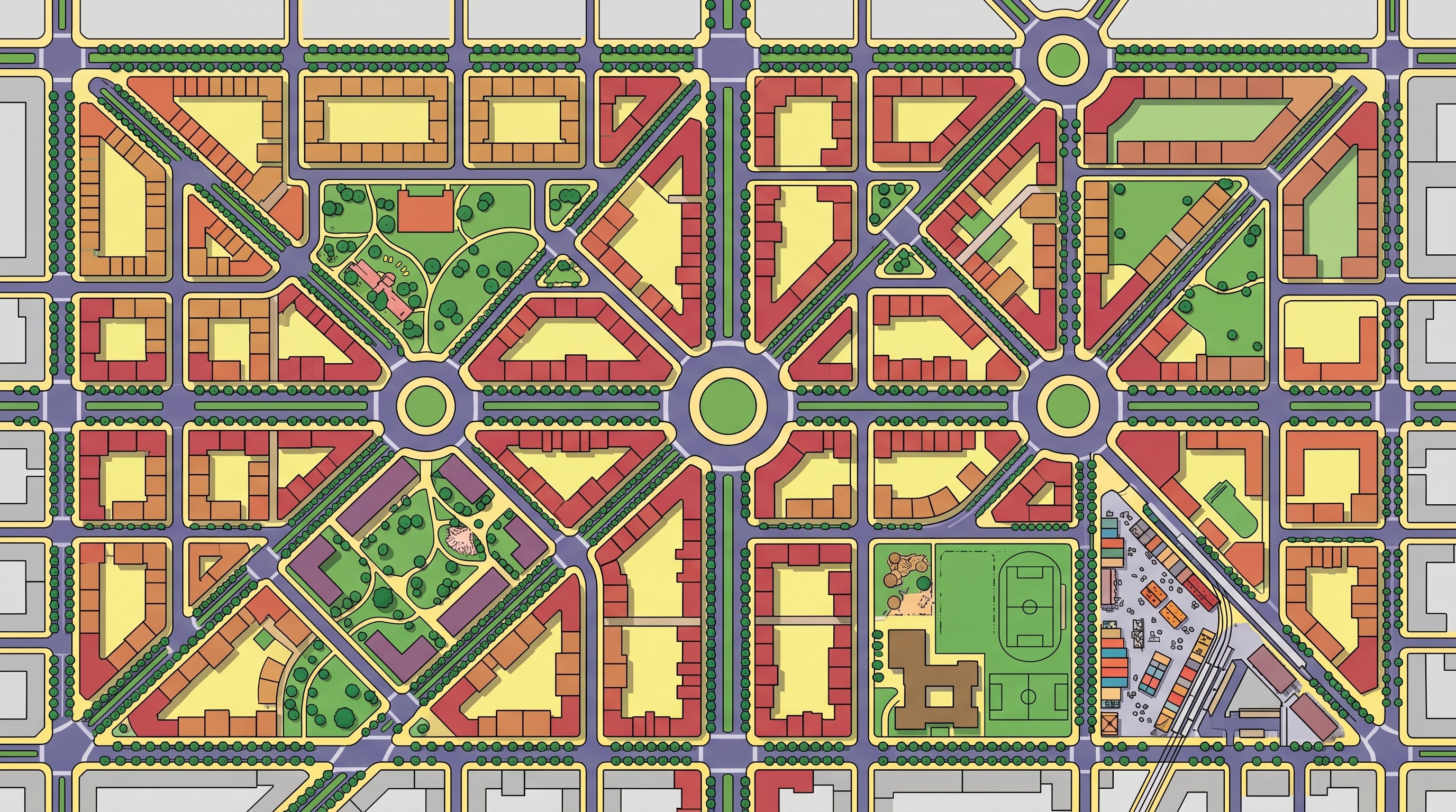
At Centrumeiland, a new district in Amsterdam’s IJburg expansion, the city is avoiding one of the great failures of contemporary urban development, the large-parcel megaproject. Rather than handing the 37 acres over to a few large developers to build massive, hotel-like buildings, Centrumeiland is subdividing the site into perimeter-block parcels, assigning each parcel a buildable role through a plot “passport,” and enabling many smaller actors to build within one coherent urban framework.
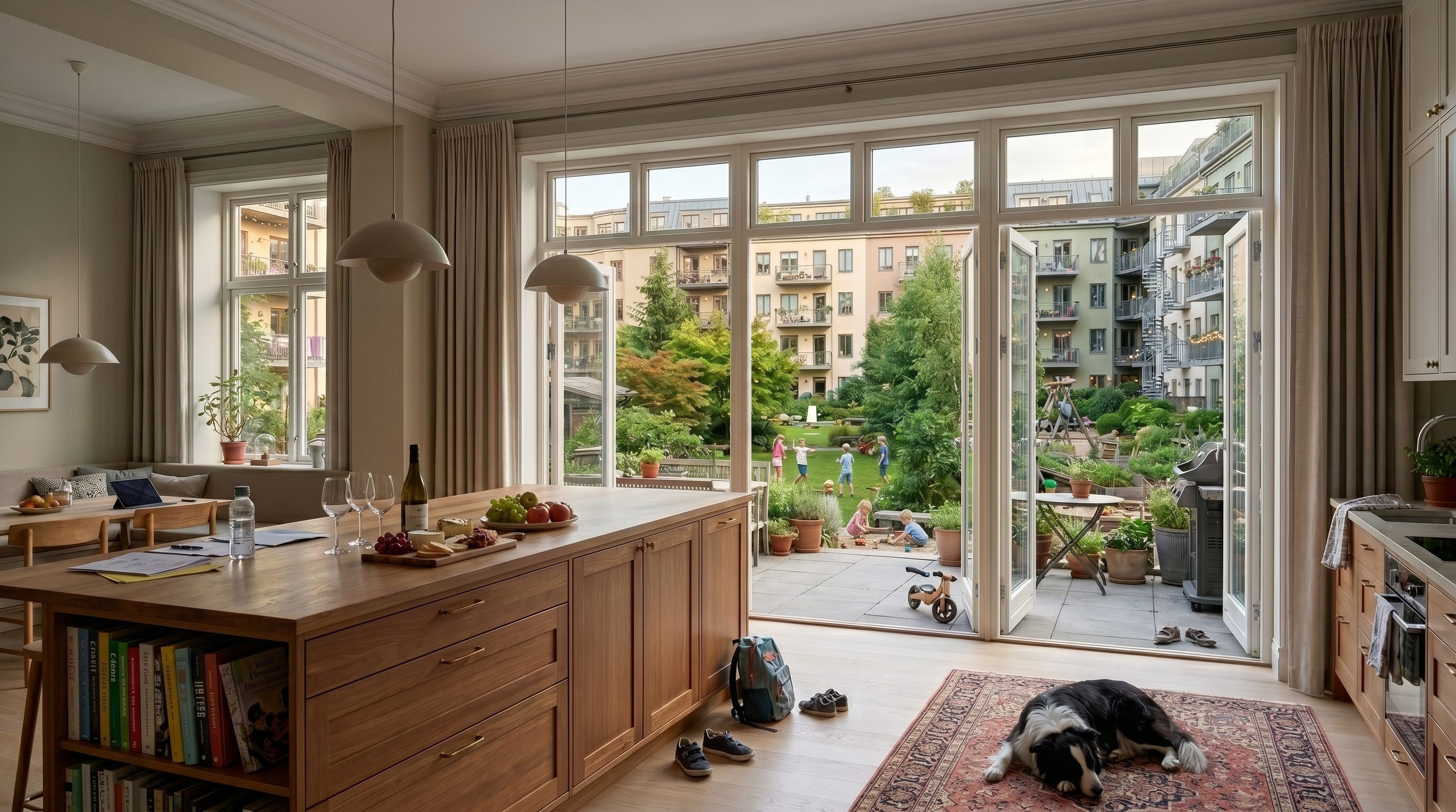
Begun in 2013 as part of Amsterdam’s IJburg land-reclamation project, Centrumeiland modernizes the old perimeter-block model for contemporary goals. It will be dense, but green; urban, but family-oriented; highly planned, but open to many builders. Amsterdam plans roughly 1,500 to 1,700 homes on the 37-acre island, or about 40 to 46 homes per acre. By American standards, that is serious density. But it is not being delivered as a monoculture of towers or double-loaded apartment blocks. Centrumeiland includes a mix of housing types and tenures: large family-sized homes, smaller rentals, social housing, mid-market housing, market-rate condos, individual self-build houses, collective self-build projects, housing-association buildings, and developer-led apartments.


The ambition is a dense urban neighborhood that can serve households across the lifecycle: singles, couples, families with children, older residents, renters, owners, and collective building groups. It also adapts the perimeter-block tradition to contemporary priorities: low-car living, accessibility, climate resilience, mixed tenure, family housing, and broader participation in development and ownership.
All of this depends on the subdivision and passport system. Amsterdam breaks the large site into many buildable pieces, assigns each parcel a role through a plot passport, and holds the pieces together through streets, blocks, party-wall conditions, courtyards, public-space rules, and environmental obligations. In this way, they have brilliantly resurrected the old urban formula that allows many builders to participate in the development of a large site, making a real neighborhood.
For American cities, the moral of the story is clear. On large brownfield and greenfield sites, cities should stop treating whole districts as single development packages to be handed to master developers. They should do the more civic work first of laying streets, subdividing land into buildable parcels, and issuing clear “parcel passports” that specify what each site can become. In existing neighborhoods, the same logic should operate at a smaller scale. Cities should create transit-oriented overlays that give ordinary private lots clear building rights that make great multifamily housing easier to finance, permit, and build.
Centrumeiland goes far beyond “build more housing.” It is more radical and more urbane. Divide the land, write good code, and let many hands build the city.
The Megadevelopment Trap
For the last half-century, large urban sites have met a sadly familiar fate. A railroad, port authority, public agency, hospital, university, or industrial landowner controls a vast tract of developable land. The master-planning process then carves it into a few enormous parcels and awards them to one or several major developers. After years of negotiation, public fights, redesigns, entitlement battles, and financing risk, the developer may finally build the megaproject, which is widely reviled by the public.
Megaprojects may be economically productive. They can deliver housing, offices, parks, retail, transit, and tax revenue. But the development model itself is thin. Too few actors control too much land. The parcels are too large, the buildings are too big, and the building code and underwriting norms push toward deep floorplates and double-loaded corridors. The buildings are dominated by small, expensive, hotel-like units that are poorly suited to middle-income families who need light, storage, bedrooms, outdoor access, and a sense of domestic permanence. These districts may be a success on paper (for now), but they make failed neighborhoods, lacking the social depths and street life that is the reward of fine-grained courtyard urbanism.


Hudson Yards, the obvious American example, is a district built with immense capital and immense floorplates, yet devoid of the personality, grain, and street-level complexity that make places like the West Village or Brooklyn’s older neighborhoods feel like true city. Mission Bay is the softer San Francisco version: economically successful, institutionally important, but still more master-planned innovation district than cherished neighborhood. Nordhavn in Copenhagen is the more sophisticated European case. It has transit, climate goals, waterfront space, and serious planning capacity, but still shows how large-parcel urbanism fails to create neighborhoods that appeal to diverse households across the lifecycle.
The problem is the development system. A megaproject cannot make a great neighborhood. Neighborhoods require many actors, many front doors, many ownership structures, many building types, many ground-floor conditions, and many small adaptations over time. They need private yards. They need a public framework strong enough to coordinate many actors.
That is the old art of division and perimeter block planning Centrumeiland begins to recover.
Making Land Into City
Centrumeiland is part of Amsterdam’s IJburg expansion, a chain of artificial islands built in the IJmeer on the city’s eastern edge. IJburg extends Amsterdam outward into the water between the historic city and the open landscape of the Markermeer, turning what was once lakebed into new urban land. Centrumeiland sits within this larger archipelago, connected back to Amsterdam by bridges, cycling routes, bus service, and the IJtram to Amsterdam Centraal. It is therefore both peripheral and deeply urban, a new island neighborhood made from water, but tied into the metropolitan fabric of Amsterdam.
While the land reclamation is impressive, even more remarkable is the public framework that governs the development. The city divided the land into kavels, and created parcel-specific rules through kavelpaspoorten, or plot passports.
A passport can define the parcel boundary, buildable envelope, maximum height, frontage condition, access requirements, open-space obligations, water-management rules, parking expectations, program, tenure, sustainability requirements, and sometimes ground-floor use. It tells a builder not merely that “residential” or “commercial” is allowed, but what kind of urban contribution this specific piece of land is supposed to make: a row of townhouses, a small apartment building, a collective self-build project, a social-housing block, a mid-market rental building, a mixed-use corner building, or a larger perimeter-block parcel with shared courtyard space.


The subdivision and passport framework enables much broader participation in the development. Of the planned 1,500 to 1,700 homes, roughly 60 to 70 percent are intended to be self-build. But “self-build” here does not only mean one household designing one eccentric house. It includes individual self-builders, small groups, collective private commissioning, building groups, housing cooperatives, and other resident-led or small-group development structures.
This should not be confused with an affordable-housing utopia. Centrumeiland includes social and mid-market rental housing, but much of the ownership and free-sector rental housing serves affluent or upper-middle-income households. Its lesson moral here is that parcelization broadens participation and creates more development pathways than the master-developer model.
Subdivision changes risk. Instead of one enormous project that must be financed, leased, absorbed, and managed as a single undertaking, the district can grow through many smaller acts of building. At this scale, these buildings will be easier to adapt over time to the changing needs of the community.
And subdivision changes the urban outcome. More parcels mean more doors, more owners, more builders, more design opportunities, more frontages, more ground-floor possibilities, and more opportunities for the neighborhood to mature over time.
How the Passport Works
The passport system turns a master plan into a set of buildable opportunities. And the user experience is relatively simple: browse the city’s parcel portal, identify a suitable kavel, download the rules, assemble the household group or development team, register during the application window, and then build under the parcel’s passport and leasehold conditions.
For a household, building group, cooperative, housing association, or developer, the process begins with a specific parcel. Amsterdam posts available kavels through its municipal self-build and land-disposition pages. Prospective builders can review the parcel online, see what category of project it is intended for, download the relevant documents, and register during the official application window.
Each parcel comes with its own package of rules: a selection brochure, parcel rules, maps, technical appendices, leasehold terms, drainage requirements, common-terrain rules, and sometimes tender documents. Together, these documents function as the kavelpaspoort, or the plot passport.
The passport tells a prospective builder: this is the piece of land; this is the role it plays in the block; this is the volume it may hold; this is the height limit; this is where the building must sit; this is how it must meet the street; this is where access and parking occur; this is how much open space must remain; this is how rainwater must be handled; and this is the kind of project the parcel is meant to receive.
Importantly, a parcel is not simply marked residential or commercial or mixed use. It may be intended for an individual self-build house, a small group of homes, a collective private commissioning project, a social-housing building, a mid-market rental block, a mixed-use corner building, or a larger apartment building organized around a courtyard condition.


The genius of the system is legibility. Ordinary households cannot negotiate a megaproject. Small builders cannot absorb a twenty-acre redevelopment district. A cooperative cannot finance and design a whole waterfront master plan. But they can evaluate one parcel if the city has already defined its size, rules, obligations, access, tenure, and development capacity.
This is what makes broad participation possible. The city breaks the district into pieces that different kinds of builders can understand, finance, and build.
The result is visible in the buildings already delivered: terrace-like self-build rows, small apartment houses, CPO projects, social and mid-market rental buildings, and larger courtyard-oriented blocks. Impressively, the district contains multiple building types and multiple tenure forms within one block structure.
Where the Model Needs to Be Stronger
Centrumeiland is not yet a full-throated revival of the great perimeter block neighborhoods of the late 19th century — not Stockholm’s Östermalm, Berlin’s Charlottenburg, Prague’s Vinohrady, or Barcelona’s Eixample reborn in the IJmeer. It lacks much of the form discipline of those older courtyard-block districts: the confident street walls, chamfered corners, piazzas, pervasive ground-floor commerce, masonry depth, ornament, and mature architectural culture that make the best European neighborhoods feel charming and sublime all at once.


A stronger passport would not need to mandate historical pastiche, but it COULD require vertical window proportions, façade depth, visible entrances, extra high ceilings on ground floors, corner treatments, roofline articulation, and enough ornament or detail to keep the street from becoming a corridor of boxes.
It should also push the default parcel size toward more disciplined mid-rise apartment urbanism.
Some individual self-build parcels at Centrumeiland are closer to house lots. That can produce charm and variety, but it is not the same as the medium-grain apartment-house fabric of the great courtyard-block districts. A stronger version of the model would include more parcels in the range of 60 to 70 feet wide, deep enough for a shallow apartment building and courtyard relationship, but not so large that the parcel becomes a megablock.
A stronger version of the Centrumeiland model would push more of the default parcel system toward medium-parcel, dual-aspect apartment buildings. A five- or six-story building on a 60- or 70-foot parcel could hold family-sized flats, smaller apartments, a point-access stair or small elevator, common storage, bike rooms, accessible ground-floor units, and flexible ground-floor commercial space where appropriate.
This is the missing scale between the self-build house and the megablock. The building is large enough for multiple households to share land, structure, stair, elevator, storage, and energy costs, but still small enough to remain fine-grained and buildable by many actors. The shallow plan allows apartments to have light and air from more than one side, making larger family units much easier to design than in a deep double-loaded corridor building. And because the homes are flats rather than stacked townhouses, they avoid the daily burden of internal stairs, which is a real benefit for parents carrying babies, toddlers, groceries, and strollers, and for older residents or anyone with mobility limitations (including senior dogs)
The ground floor also becomes more useful. A 60- or 70-foot frontage can accommodate a small shop, clinic, studio, or café where the street calls for commerce, while still leaving room for storage, bikes, trash, building services, an accessible unit, or a modest garage condition where needed. It would still be fine-grained. It would still allow many builders. But it would have enough urban weight to support street life, shared costs, family housing, and a more durable neighborhood fabric.
Centrumeiland recovers the development system. The next step is to recover the urban grammar.
The American Application
For American cities, the lesson is to create a modern urban passport system.
There are two obvious applications: large-site development and existing-neighborhood overlays.
On brownfield and greenfield sites — former industrial land, rail yards, malls, hospital campuses, public land, waterfronts, and other large redevelopment areas — cities should stop defaulting to the megaproject model. They should lay out streets first, shape interesting blocks, design public spaces, subdivide land into buildable parcels, and assign parcel passports. Those parcels could then be allocated to many actors: small developers, cooperatives, housing associations, community development corporations, nonprofit builders, resident-led groups, and larger developers where appropriate.
Large developers may still participate. But they should not control the whole district. The city should not ask one actor to simulate the complexity of a neighborhood.
The quality of the neighborhood is determined upstream: street geometry, block structure, parcel dimensions, public-space hierarchy, and rules of participation. If the streets are dull, the blocks oversized, the parcels too large, the ground floors dead, and the whole site controlled by one capital stack, no amount of façade variation will create a great neighborhood.
The second application is existing neighborhoods, especially transit-oriented districts. Here, cities do not need to make new land or assemble huge sites. They need zoning overlays that make good urban buildings legal, predictable, and easy to permit.
A parcel-passport overlay could define permitted building types by lot width and depth; replace suburban setbacks with build-to lines; allow party-wall construction; set courtyard or rear-yard requirements; establish height ranges, ground-floor rules, corner standards, parking maximums, façade standards, stormwater rules, and pre-approved building types.
On private land, the American version would differ from Amsterdam’s leasehold-based system. Cities would more often use zoning overlays, subdivision rules, Planned Development reform, parking reform, pre-approved plans, and entitlement incentives. But the logic can travel.
For ordinary private lots, the passport could be an opt-in fast track: follow the rules and receive predictable approval, more units, less parking, and fewer discretionary fights. For large sites seeking upzoning, public subsidy, infrastructure support, or Planned Development approval, the passport system should be mandatory. If a landowner wants the public value of a major entitlement, the city should require a public urban framework in return.
Modernizing the Perimeter-Block Code
The goal is not to recreate the 19th century. It is to recover what the 19th century understood about city-making and update it for contemporary needs.
The 19th century gave us the street plan, the parcel, the perimeter block, the party wall, the courtyard, the street wall, and the mixed-use ground floor. It gave us a system in which many builders could produce coherent urban fabric because the public rules were strong enough to coordinate private action.
The 21st century should keep that logic, but give it new obligations: climate adaptation, stormwater management, tree canopy, heat mitigation, universal accessibility, low-carbon construction, energy performance, affordable housing, family-sized flats, bike storage, car-light living, childcare, prefabrication compatibility, fire safety, and mixed-income ownership models.
It should also make collective self-development easier. Self-build does not have to mean one household designing one house. At urban scale, it can mean ten or fifteen households forming a building group, cooperative, or resident-led development entity to commission one mid-rise apartment building within a city-defined parcel and code.
But that cannot happen without the right sites and the right development framework. Households cannot collectively build a neighborhood from scratch. Small builders cannot absorb a megaproject. Cooperatives cannot invent the parcel, the code, the financing pathway, the fire-access strategy, the courtyard rules, and the entitlement process every time they want to build.
Amsterdam’s subdivision and passport system gives the city a way to create many buildable pieces, assign each one a role, and invite many actors into the work of development without surrendering urban coherence.
For American cities, the moral of the story is that we do not need to choose between the megaproject and the detached house, between master-developer monoculture and atomized individualism. In the better model, the city lays out the streets, shapes the blocks, divides the land, writes the passports, and lets many hands build.
Courtyard Urbanist helps cities, developers, institutions, and public agencies create subdivision and passport systems for courtyard-block neighborhoods: street and block plans, parcelization strategies, form-based rules, building-type standards, courtyard requirements, and implementation frameworks that make fine-grained urban development easier to finance, permit, and build.
If your city, agency, institution, or development team is working on a large site — or wants to create a zoning overlay for better multifamily neighborhoods — we would be happy to talk.
Email us at projects@courtyardurbanist.com.

Thanks for the excellent view and explanation of Centrumeiland. It's great how it makes urban living accessible to housholds by offering individual sites, especially to housing cooperatives. Inspiration for other European countries too!
Your overview of the less-strong aspects, like lack of ground-floor commercial units, made for a very balanced assessment.
Ciarán Breen
The role of limited equity cooperatives (in the American parlance) needs more (some) discussion.
You’re doing great work!