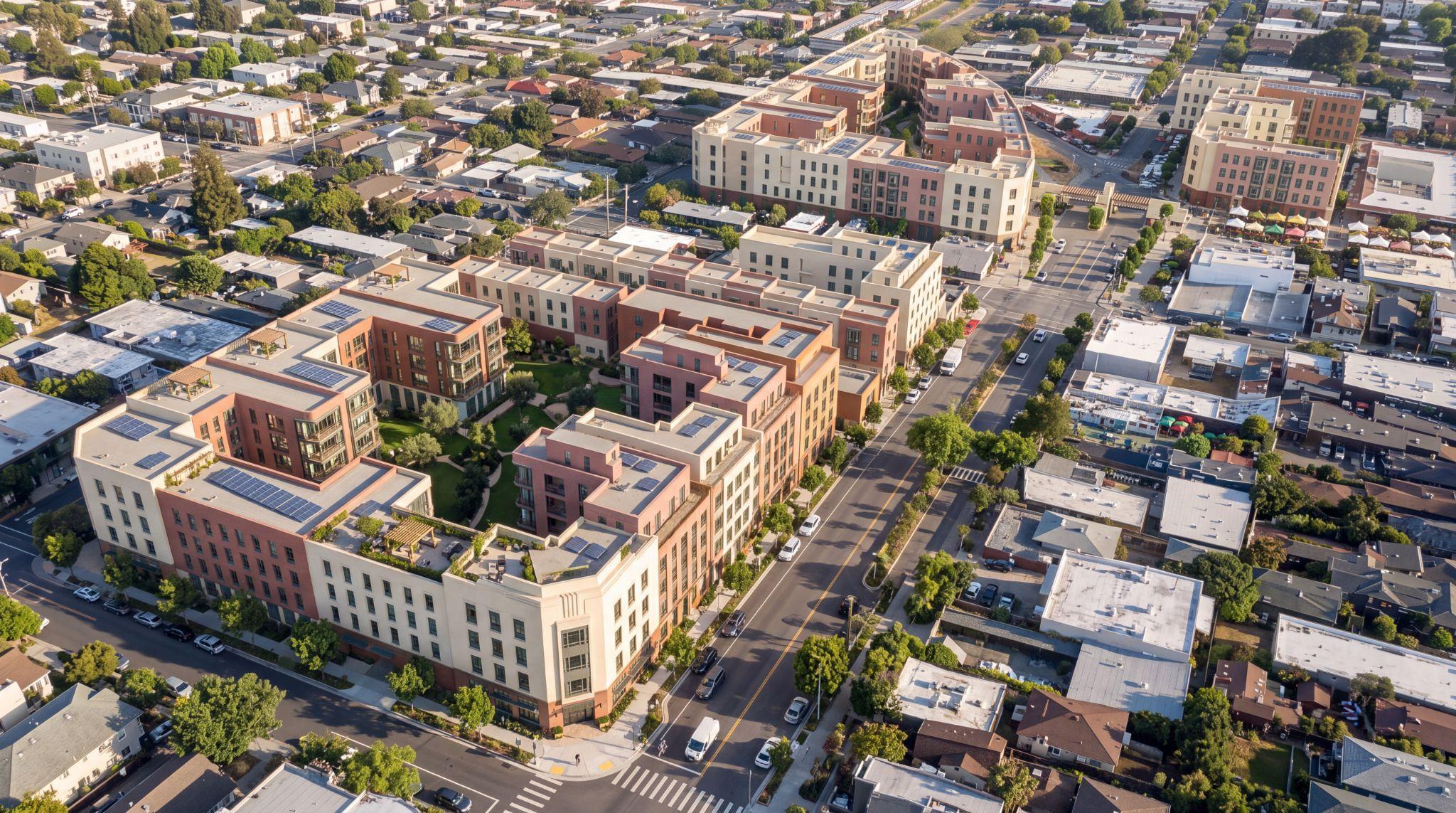
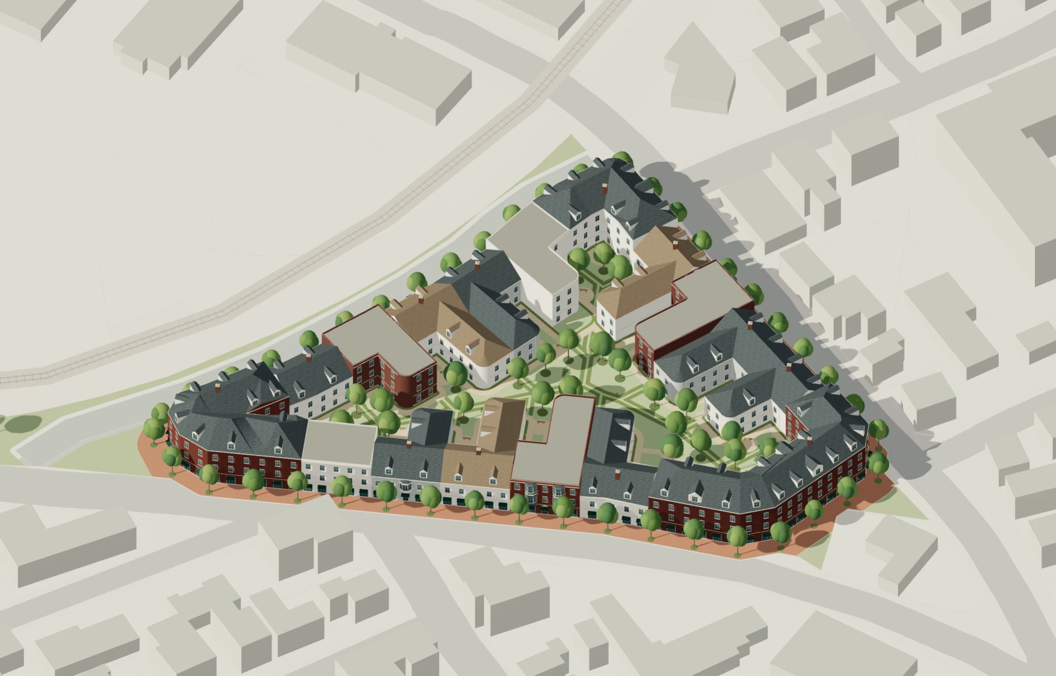
A possibility grounded in place. Explore the courtyard proposal in its GIS-informed neighborhood context, then see an inhabited vision of the same study.
Mission Bay · San Francisco
Mission Bay 24 buildings · 2 courtyard gardens
↑N
Loading the neighborhood model…
Courtyard proposalExisting context
Drag sideways to orbit. Use the view buttons to explore. Keyboard: arrows rotate, +/− zoom, Home resets.
01 · A study grounded in placeOriginal model geometry aligned with GIS streets and building context.02 · The photorealistic visionMaterials, planting, light and everyday activity bring the concept to life.
About the study & map sources
This interactive view uses the same 24-building proposal as the Google Earth file, with schematic neighborhood context from OpenStreetMap and San Francisco GIS. It is a local model viewer; satellite imagery is not included. Geographic alignment is conceptual (approximately ±10–15 feet); contextual heights and street details are approximate. The rendering is an illustrative interpretation, not a surveyed reconstruction.
Help people picture your courtyard concept with five photorealistic views of the project.
For site conversations, presentations and sharing the possibilities with others. Arrange this separate package by email; it is not included in site-planning checkout.
Plan licensing starts with a conversation. No plan is presented as ready to purchase, permitted or approved for a particular site. Professional design, engineering and local review remain separate project needs.
Identify a site for a courtyard block: city-owned land or land available to be assembled. Work with Courtyard Urbanist to explore the site’s potential and develop a concept for your neighborhood.
Your project pageConcept site plan · Massing · Building program · Area information
Site planning · $1,000 minimum through 1 acreBeyond 1 acre, add $250 for each quarter acre, rounding additional acreage up to the next quarter acre. Available through 5 acres, with one revision per project included. For uncertain acreage or sites above 5 acres, request an exact quote. Larger sites welcome.
Separate rendering package: five photorealistic renders for $1,000, arranged by email and not included in checkout.
Work with Courtyard Urbanist and your planning team to develop a zoning overlay for appropriate areas—near transit, schools, churches, or business districts. Model how different options could transform a neighborhood over years and decades.
Possible scopeStudy area · Overlay framework · Long-term scenarios
Invite Courtyard Urbanist to present the courtyard urbanism approach to city staff, developers, community stakeholders, and the fire department. Use presentations and workshops to explore examples, discuss local questions, and hear feedback.
Possible scopePresentations · Stakeholder workshops · Technical discussions
An exterior stair connects the rear landings. Windows and a ground-floor door face the courtyard.
3-bed + office simplexWest 2-bedEast 2-bedShopsRear stair & elevator
Unit mix scenario
2 × 3BD + office · 6 × 2BD
One full-floor simplex on each of levels 1 and 2.
12,000 Total GSF10,000 Upper-floor GSF2,000 Ground-floor GSF
50′ × 40′ × 6 floor plates · Exterior stair and open landings excluded.
Floor-by-floor areas
Illustrative floor area and home mix
Level
Program
Home target*
GSF
Total gross floor area
12,000
*Approximate home areas, not gross floor areas. Each 1,645-sf simplex carries forward half of the former duplex target; the 780-sf and 710-sf targets are unchanged. Total home area: about 7,830 sf.
GSF includes walls, elevator, shared circulation and support within the main building. Ground-floor GSF includes residential access as well as the shops. The mansard assumes the full floor plate; its home target allows for the roof slope. These are planning assumptions, not measured room layouts.
Explore Courtyard Urbanist building types such as Fifty Forty and the point-access ELL, then co-develop them with a local architect so façades and building form respond to local conditions. Develop a locally adapted collection for your city’s pattern book or demonstration project.
Possible scopePrototype selection · Local architectural collaboration · Licensing
These concept projects imagine what real sites could become—from a neighborhood corner to a city riverfront. They are explorations of possibility, created to spark the imagination about courtyard life.
CONCEPT PROJECTS · Ideas to inspire what sites could become.
Penn Plaza · Courtyard Urbanist concept illustration
Study site
≈4 acres
Individual buildings
36
Concept homes
≈423
Stories
5–6
The idea
A square for the city. Gardens for everyday life.
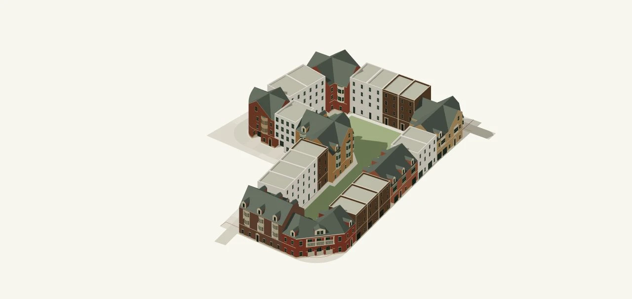
The Block B study assembles Fifty Forty and Sixty Forty building types around two protected gardens. A public square opens north to Penn Avenue, bringing markets, dining and neighborhood life into the block.
01
Individual addresses
Distinct entrances, façades and rooflines allow a large site to read as many apartment houses.
02
Shared outdoor rooms
Homes overlook planted courts, while the public square remains open to the surrounding neighborhood.
03
A working program
The early massing estimates about 455,000 gross square feet, including roughly 33,000 net square feet of commercial space.
Concept study; quantities are preliminary and subject to design and feasibility testing.
The public square and colonnade at evening.Plate 07 · Building arrangement and shared open space.
Mission Bay · Courtyard Urbanist concept illustration
Buildings in the model
24
Courtyard gardens
2
Public piazza
1
Neighborhood context
GIS
The idea
From a vacant site to a living neighborhood.
The study brings individual buildings together around planted residential courts and a central public space. Street-facing shops, dining and roof terraces give the proposal places for both neighborhood activity and quieter life at home.
01
A connected public realm
A fountain piazza links the blocks, with active ground floors facing the street and square.
02
Gardens close to home
Two sheltered courts gather the green space where residents can see and use it.
03
Explore the model
Rotate the original proposal in its geographic context, switch to the rendering, or download the Google Earth file.
Concept massing and illustrative rendering; geographic alignment and surrounding building heights are approximate.
A familiar corner. A new neighborhood possibility.
CONCEPT PROJECT · Mixed-use courtyard vision
Western & Lawrence · Courtyard Urbanist concept illustration
Study site
≈2 acres
Concept homes
200–240
Stories
6
Commercial space
20–26k sf
The idea
A bank can anchor a whole neighborhood.
The concept replaces drive-through infrastructure and surface parking with mixed-use buildings. A compact bank branch stays at the corner, alongside shops, family-sized homes and a courtyard held in common.
01
Keep the corner active
A bank and neighborhood storefronts address Western, Lawrence and the civic plaza.
02
Preserve the center
The interior becomes a planted shared yard, overlooked by apartments and protected from traffic.
03
Make room for many hands
Coordinated development pads could allow several builders to contribute within one landscape and entitlement plan.
Illustrative capacity study. Construction costs, financing, land arrangements and approvals remain to be tested.
The existing corner and the proposed street frontage.A civic plaza connects the block to neighborhood life.
Chicago Riverfront · Courtyard Urbanist concept illustration
Study site
2.61 acres
Concept homes
260
Gross square feet
≈358k
Concept building levels
6 + setback
The idea
The river becomes a neighborhood address.
This alternative for the RiverWard site tests a courtyard neighborhood against the approved 49-townhouse plan. Individual party-wall buildings enclose gardens and open to a riverwalk, restaurants, public steps and a piazza on the North Branch.
01
A family-sized mix
The study includes 52 four-bedroom homes with offices, 91 two-bedrooms, 78 one-bedrooms and 39 studios.
02
A generous waterfront
Active ground floors and broad public spaces bring everyday neighborhood life to the water.
03
A planted interior
About half the site remains unbuilt, accommodating courtyards, passages and shared outdoor space.
Courtyard Urbanist alternative concept; the 260-home scheme is not the approved RiverWard development.
Approaching the neighborhood from the North Branch.Homes overlook a sheltered shared garden.
The concept imagines the lands around the Gateway Arch as a walkable mixed-use district. Courtyard buildings and public riverfront spaces bring homes and everyday activity into the setting of the monument.
01
City and monument
The Arch remains the landmark within a more continuous neighborhood fabric.
02
Life along the river
The illustrations explore building fronts, gathering places and pedestrian routes beside the water.
03
An invitation to discuss
This is an independent design provocation about what the area could become.
Independent speculative concept; not a National Park Service proposal or an approved development.
An imagined riverfront promenade and neighborhood edge.
We’re looking for manufacturers and suppliers with APIs, structured product, specification and pricing data, or agent-ready workflows who would like to explore connecting with the Courtyard Urbanist design system.
Secure Stripe checkout. Confirm the same total and exact acreage before paying.
After payment, email your site brief and outlined aerial. Alicia will match the acreage, brief and successful payment before starting work.
What’s included & how it works
Your page brings together interactive block and building models, roof plans, ground-floor plans and street views, plus building footprints, floor areas, stories, estimated home counts and parking schedules. These are concept studies, with one revision included.
Calculate and check out. Enter your actual acreage, including decimals. Confirm the total in Stripe and enter your name, email, project label and the same exact acreage. Return here to recalculate if the area changes.
Email your private brief. Use the email template above. Add the site location, what you’d like to explore, and an aerial with the parcel outlined. Include the same project label and purchaser email, plus your Stripe receipt or payment reference.
Alicia matches your order. Work begins after the acreage, brief and successful payment match. Public use of your name, image or project details requires separate approval.
The site does not upload or store your aerial. The brief link opens your email app; attach the image and receipt there. Send only an image you have permission to share privately with Alicia.
How acreage pricing works
The $1,000 minimum covers sites through 1 acre. Each additional quarter acre is $250, rounded up, through 5 acres. Larger sites and uncertain acreage need a quote before payment.
1.2 acres → 1.25 billed
$1,250
1.5 acres
$1,500
2.3 acres → 2.5 billed
$2,500
5 acres
$5,000
Above 5 acres
Request a quote
See an example
Candlestick
Explore a site plan, massing, program and areas together in one project page.
Five photorealistic views are a separate optional $1,000 package for site conversations and presentations. They are not included in the planning total.
Community funding is being prepared. Pledges are not open.
Email Alicia your site location, approximate acreage, idea and an outlined aerial for private review. An approved campaign would need provider confirmation and an agreed scope and goal before opening.
The planned process is pledge first, with charges only when the approved goal is reached and work starting after sufficient funds are collected. Public use of your name, images and site details needs separate approval.
Courtyard Urbanist · Principles, barriers & local readiness
What does it take to make courtyard urbanism possible?
Explore the building principles, the rules that get in the way, and practical reforms. Then check what is known about your city.
01 · The design principles
What courtyard urbanism needs.
Street-facing buildings, a shared green interior and enough homes to make a neighborhood. Dimensions are study targets, adjusted to each site.
01
Buildings that make a street
Buildings face the street, with individual entrances and connected street walls. Party walls let neighboring buildings work together.
02
Modest, independent buildings
Ordinary buildings target 50–60 ft of frontage and roughly 2,000–4,000 sq ft footprints, with coherent larger corners where needed.
03
A shared green courtyard
Buildings frame a useful garden inside the block. Preserve daylight and accessible passages; keep parking and servicing from consuming the court.
04
Enough homes on the land
Study five to six stories, with alternatives where appropriate. Height, floor area, dwelling count and open space must work together.
05
Practical stairs & elevators
Make modest buildings practical with appropriately sized stairs, elevators and entrances, while retaining life safety and accessibility.
06
A neighborhood that can grow in pieces
Allow small parcels, multiple builders, shared-courtyard ownership and neighborhood-serving shops, with workable servicing and phased construction.
Dimensions behind these principles See our study targets
The study covers building form, housing capacity and requirements that add construction cost, operating cost or delay.
For the Seattle height comparison, the taller study is tested at 60 feet. A measured site plan is needed to establish site-specific capacity.
02 · Barriers & fixes
Common barriers. Practical reforms.
See what gets in the way and how to change it. Open a card for specific fixes, model language and examples.
Green highlights the part of the block each reform affects. These are common issues to investigate locally. Model language is our draft for adaptation; examples retain their own conditions and limits.
No matching reforms. Try another keyword or clear your search.
Research behind the reforms 24 research topics · studies, reform efforts & local questions
Explore the evidence on costs, housing capacity and efforts to change the rules.
These documented reform efforts identify questions to investigate here. An adopted example applies in its stated jurisdiction; a proposal or advocacy campaign does not establish current local law. Cost effects are qualitative unless a cited local estimate is available.
Authors & organizations Stephen Smith & CBNA · Mercatus · HUD · Neptis · Pew and others
Follow the original work and explore the reforms it informs. Each citation identifies research, policy recommendations, official guidance or law. Inclusion is not an endorsement of this tool by an author or organization.
03 · Your city’s readiness
Where does your city stand?
Explore verified rules and remaining questions. Provisional ratings describe the places and building types reviewed.
Choose your location
Start with an initial city review
Source checks · October 10–11, 2026
Search 32,363 U.S. Census places using the same 43 checks. These three cities have some initial research; other cities begin with an unrated checklist.
Courtyard urbanism readiness
Your city’s scorecard
Eight areas · one consistent checklist
Overall rating
Research coverage
Findings cover the rules and scenarios stated. A topic may still need further research; this is not a measure of citywide feasibility.
How to read this scorecard
A barrier is a restriction established for the stated scenario. A pathway is an existing permission with conditions. Mixed evidence shows both. “Needs research” is neither a pass nor a failure. An address search provides city context until the parcel’s rules are verified.
Equal checklist coverage is not equal economic impact. This first version does not assign weights, estimate savings or rank cities from incomplete examples.
The starting point
Check the rules here
Local findings & the full checklist
Separate verified requirements and existing permissions from the questions that still need local evidence.
Sources and coverage
From a finding to a first project
Make a local plan for courtyard urbanism.
A development audit or zoning-overlay study can turn these questions into a focused next step.
Research and planning aid. Confirm current rules and site-specific conclusions with the relevant authority and professional team. A city overview does not establish permission for a particular parcel.
Method, coverage & privacy
Each local finding compares a stated courtyard scenario with cited primary sources. “Already enabled” always retains the listed conditions. A missing rule is marked “Needs verification.” The separately versioned reform agenda records movements and official studies using their own primary sources. Advocacy, proposals, studies and adopted examples have distinct labels; none automatically changes a local finding. Source checks are initial research, with editorial review pending.
City names come from the 2026 U.S. Census Gazetteer. Address matching uses Census address-range interpolation and its returned geography. A mailing city or Census statistical place is not proof of a permitting jurisdiction. In San Francisco, approximate point matches can also retrieve parcel candidates, zoning, height and special-use districts from Planning GIS; they need confirmation in the official property map.
City searches run against our place directory. Address queries are sent to the Census Geocoder; San Francisco coordinates are sent to Planning GIS. This application does not save raw searches, exact-address reports, or property-owner information. Providers and hosting infrastructure may have their own access records. Address results remain in memory in this tab until you clear or leave it. Downloading or printing intentionally creates your own copy.
Shared links contain a city ID and an immutable local-research version, never your address. The current reform agenda and model-clause library are shown alongside that local snapshot; downloads record their versions. Draft reforms and other jurisdictions’ examples do not change local findings or readiness ratings. Sources older than 45 days are marked for rechecking. No model invents findings when research is missing. No paid research API is used in this initial release.